
Administrator
22 December 2025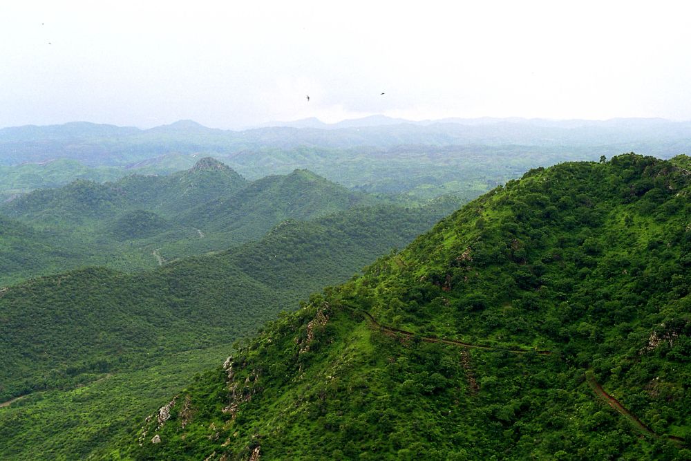
The Supreme Court of India, in its order dated November–December 2025, considered the recommendations of the Committee constituted by it vide order dated 9/5/24 and its further directions dated 12/8/2025 regarding uniform policy level definition of Aravali Hills and Ranges specifically in the context of regulating mining, and to incorporate the views of the concerned State Governments.
Ministry of Environment, Forest and Climate Change (MoEFCC) led this Committee comprising Secretaries of departments of forest from UT of Delhi, Haryana, Rajasthan, Gujarat as well as representatives of Forest Survey of India, Central Empowered Committee and Geological Survey of India.
The Court emphasized the ecological importance of the Aravalli range as a barrier against desertification, a groundwater recharge zone, and a biodiversity habitat
Importance of Aravallis
The Aravalli Hills and Ranges are among India’s oldest geological formations, stretching from Delhi through Haryana, Rajasthan, and into Gujarat. Historically, they have been recognized across 37 districts by state governments, with their ecological role noted as a natural barrier against northern desertification and a protector of biodiversity and water recharge. The Supreme Court has emphasized that uncontrolled mining here poses a “great threat to the ecology of the nation” and directed uniform criteria to safeguard them. Their conservation is thus vital for ecological stability, cultural heritage, and sustainable development.
M/o EF&CC Committee Report Findings
The Committee, constituted by MoEF&CC pursuant to Supreme Court directions had extensive consultation with State Governments in which it emerged that only Rajasthan has a formally established definition for regulating mining in the Aravalli definition which was based on the 2002 Committee Report of the State Government relying on Richard Murphy landform classification which Identified all landforms rising 100 m above local relief as hills and based on that , prohibiting mining on both the hills and its supporting slopes. State of Rajasthan has been following this definition since 9th January, 2006. During deliberations, all States agreed to adopt the aforementioned uniform criterion of “100 metres above local relief” for regulating mining in the Aravalli region as had been in force in Rajasthan since 09.01.2006 while unanimously agreeing to make it more objective and transparent. All the landforms enclosed within the lowest binding contour encircling Hills of height 100 metre or more irrespective of their height and slopes are excluded for the purposes of grant of mining lease. Similarly, Aravali range has been explained as all the landforms which exists within 500 metres of two adjoining Hills of height 100 metre or more. All landforms existing within this 500 metre zone irrespective of their height and slopes are excluded for the purposes of grant of mining lease. It is, therefore, be wrong to conclude that mining is permitted in all landforms below 100 metre height. The Committee constituted by the Supreme Court proposed several improvements over the definition currently followed by Rajasthan to strengthen it and to make it more transparent, objective and conservation centric:
The aforesaid measures ensure a clear, map-verifiable operational definition of “Aravalli Hills” and “Aravalli Range,” and a regulatory framework that protects core/inviolate areas, restricts new mining, and hardens safeguards and enforcement against illegal mining. In its final judgment dated 20.11.2025, the Hon’ble Supreme Court commended the Committee’s work including the assistance of the Technical Committee (para 33 of the Order) and also appreciated its recommendations regarding prevention of illegal mining and permitting only sustainable mining in Aravali Hills and Ranges (para 39 of the Order). The Supreme Court has accepted these recommendations and imposed an interim moratorium on new leases until a landscape-wide MPSM is prepared.
Operational Definitions
Aravalli Hills: Any landform located in the Aravalli districts, having an elevation of 100 metres or more from the local relief, shall be termed as Aravalli Hills. For this purpose, the local relief shall be determined with reference to the lowest contour line encircling the landform (as per the detailed procedure mentioned in the Report). The entire landform lying within the area enclosed by such lowest contour, whether actual or extended notionally, together with the Hill, its supporting slopes and associated landforms irrespective of their gradient, shall be deemed to constitute part of the Aravalli Hills.
Aravalli Range: Two or more Aravalli Hills, as defined above, located within the proximity of 500m from each other, measured from the outermost point on the boundary of the lowest contour line on either side forms Aravalli Range. The area between the two Aravalli hills is determined by first creating buffers with a width equal to the minimum distance between the lowest contour lines of both hills. An intersection line is then generated between the two buffer polygons by joining the intersection of both buffer polygons. Finally, two lines, are drawn perpendicularly from both endpoints of the intersection line and extended till it intersects the lowest contour line of both hills. The entire area of landforms falling between the lowest contour lines of these Hills as explained, along with associated features such as Hills, Hillocks, supporting slopes, etc., shall also be included as part of Aravalli Range.
These definitions are not just technical but they are ecological safeguards. By clearly identifying what counts as an Aravalli Hill or Range, they ensure that all critical landforms, slopes, and connecting habitats remain under statutory protection, thereby preventing ecological degradation.
How the Aravallis Are Protected
The Committee’s findings, later upheld by the Supreme Court, provide a clear scientific basis for identifying the Aravalli Hills and Ranges. These findings, combined with strict mining regulations and monitoring, ensure that the ecology of the Aravallis remains safeguarded and free from imminent threat.
Safeguards for Mining and Ecological Protection
The findings upheld by the Supreme Court set out strict measures to ensure that mining does not compromise the ecological integrity of the Aravallis. These safeguards combine absolute prohibition in sensitive zones, sustainable mining practices, and strong enforcement against illegal operations.
Conclusion:
The Aravalli Hills remain under robust protection through the Ministry of Environment, Forest and Climate Change and coordinated efforts with state governments. The Government reiterates its commitment to ecological preservation, sustainable development, and transparency.
Contrary to alarmist claims, there is no imminent threat to the Aravallis’ ecology. Ongoing afforestation, eco-sensitive zone notifications, and strict monitoring of mining and urban activities ensure that the Aravallis continue to serve as a natural heritage and ecological shield for the nation. India’s resolve is clear: the Aravallis will be safeguarded for present and future generations while balancing conservation with responsible development.