Administrator
13 October 2026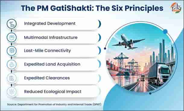
PM GatiShakti is guided by six principles that seek to make infrastructure planning more integrated, efficient, and coordinated. This includes integrated development, multimodal infrastructure, last mile connectivity, expedited land acquisition, minimised clearances and reduced ecological impact.
Key features of PM GatiShakti include:
|
Do You Know? |
|
ITLA: Strengthening Integrated Transport Planning Complementing PM GatiShakti, the Union Cabinet recently approved the establishment of the Integrated Transport & Logistics Authority (ITLA). The Authority will focus on long-term transport planning and coordination.
ITLA will prepare a National Transport Master Planwith a planning horizon of ten years or more. It will assess sectoral and annual transport plans, and undertake technical appraisal of projects costing ₹500 crore or more. The authority will also monitor their implementation. It will also develop a National Transport Data Repository (NTDR) by integrating information from sources such as FASTag, Vahan, and GSTN e-way bills. |
How GatiShakti Works: From Coordination to Project Planning
PM GatiShakti has a three-tier institutional frameworkcomprising the following:
As of 11 August 2026, the NPG had evaluated 396 infrastructure projects with a total estimated cost of about ₹18.66 lakh crore. Of these, 256 projects had been sanctioned, of which 198 were under implementation. The institutional framework is supported by a digital platform that provides planners with geospatial data, satellite imagery and analytical tools.
Gati Shakti Vishwavidyalaya: Building Expertise for Integrated Infrastructure Planning
Gati Shakti Vishwavidyalaya (GSV) is a first-of-its-kind university focused exclusively on the transport and logistics sectors. Established in 2022, the university brings together education, executive training and research across transport-related disciplines.
GSV supports the PM GatiShakti National Master Plan and the National Logistics Policy (2022) through specialised education, training and research. GSV serves as a nodal agency for developing and delivering courses on both initiatives. The collaboration also envisages knowledge centres to share best practices and promote research and innovation in logistics. As of July 2026, the university had trained more than 2.4 lakh officers through courses designed for PM GatiShakti. The university is also expanding its focus on applied research for integrated transport planning, alongside specialised areas such as maritime transport, bridge and tunnel engineering, and defence logistics.
From Data To Decisions: How Digital Planning Is Helping Planners
The NMP brings together GIS-based data on infrastructure, geographic features, and demography on a common platform. Economic zones are also mapped alongside multimodal connectivity infrastructure to support integrated infrastructure planning. This enables planners to view different infrastructure networks and relevant geographic information together while planning projects.
The platform combines spatial planning and analytical tools with mechanisms for updating and integrating data. It can support activities such as adding project information, measuring proximity, identifying Go/No-Go areas (areas where development may be restricted) and obtaining clearances.
Mapping Infrastructure and Infrastructure Nodes
The PM GatiShakti NMP maps economic, social and logistics nodes alongside multimodal connectivity infrastructure. This brings infrastructure linkages and the surrounding development context into the planning process. The platform helps identify infrastructure linkages required to support economic zones and development projects, as well as missing connectivity gaps that can affect the seamless movement of people, goods and services.
Economic zones such as textile and pharmaceutical clusters, defence corridors, electronic parks, industrial corridors, fishing clusters and agri zones are mapped to support integrated infrastructure planning.
Example: Khagaria–Purnea corridor in Bihar. The upgraded corridor is planned to connect five PM GatiShakti Economic Nodes, including a textile cluster, Mega Food Parks and fishing/seafood parks, along with 11 logistics nodes. The planned connectivity is intended to facilitate faster movement of goods and passengers across the region.

Connecting Logistics Systems
Unified Logistics Interface Platform (ULIP) enables API-based integration of government logistics systems, while the Logistics Data Bank (LDB) provides real-time tracking of EXIM container movement. Together, they strengthen digital information exchange and visibility across the logistics ecosystem. As of July 2026, ULIP connected 46 government systems across 12 Central Ministries through 142 APIs.
Opening Geospatial Data to Wider Users
The digital ecosystem has also expanded beyond government users. In October 2025, the PM GatiShakti NMP platform was opened to the private sector through a Query-Based Analytics Mechanism developed by Bhaskaracharya National Institute for Space Applications and Geo-informatics (BISAG-N). The platform provides regulated access to selected non-sensitive datasets for infrastructure planning and investment decisions.
The platform currently provides access to 230 approved datasets covering physical and social infrastructure assets. Users can undertake site suitability analysis, connectivity mapping, alignment planning and compliance checks, and generate analytical reports.
From Data to Monitoring
The digital platform also supports the tracking of project progress and updating of infrastructure data. The PM GatiShakti NMP Dashboard provides multi-sector reporting to track progress and derive actionable insights. The Data Uploading and Management System (DUMS) enables decentralised and real-time data ownership and updating.
The overall approach uses geospatial data, satellite imagery and API integration to support data-driven decision-making, planning and optimisation of infrastructure development.
PM GatiShakti in Action
Building a Connected Infrastructure Future
Five years after its launch, PM GatiShakti has evolved from a national infrastructure planning initiative into a wider digital planning ecosystem. Its expansion across Ministries, States, districts and new infrastructure domains is creating a more integrated approach to planning India's next generation of infrastructure.
If you value our journalism, consider making a voluntary contribution to help us continue bringing news, stories and information to our readers.
Scan the QR code to contribute

Every contribution, big or small, is appreciated.